
MyTechDailyNews General: A City Solar Photo May Beat the Usual Sun-Aiming Rule for Panel Tilt
If a small solar panel is mounted between tall buildings, the usual shortcut is easy to misunderstand. People assume that simply making the panel “point it at the sun’s maximum” is enough. In a dense streetside environment, nearby façades, limited sky view, shading, and reflections change the light path. For MyTechDailyNews readers who see solar devices on charging stations, kiosks, and signage, the practical question is not only how the panel is built, but where it faces.
A research team in the Engineering School at Columbia University in New York proposed using one spherical image from the target site to estimate a year-round optimal fixed orientation. The method considers sun angle, nearby shading, diffuse light from a partially visible sky, reflections off windows, and building façades. The team described these local conditions as the so-called “urban canyon.” It said the system can raise capture by 10% to as high as 30%, with no extra cost.
Why city light paths are harder than open fields
Power management begins at the light-capture side. In an open setting, photovoltaic panels can follow a relatively straightforward plan: receive as many incoming photons as possible, and use mechanical solar tracking when possible. That plan is difficult to treat as universal in cities. Buildings can block direct sun, cast moving shadows, and redirect light from glass and façades. Those local effects are especially important for small fixed panels that serve localized, not grid-connected uses.
Tools exist to evaluate the actual installation site, but common site assessments may still be incomplete. A panel’s irradiance is often assessed with a 3D model, but such models can miss small nearby structures that influence light paths and net irradiance. Because increasing the panel’s own efficiency is difficult, improving energy capture at the front end is worth attention.
How one spherical image is turned into an orientation guide
The method first reads shadows and straight lines in the photo to establish camera orientation. It then segments the image to judge how different frame elements contribute to total power generation.
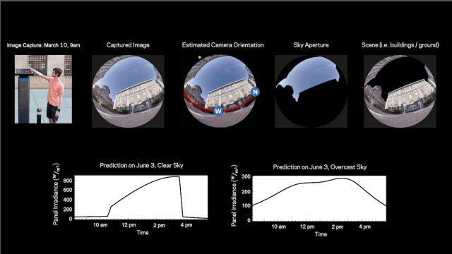 Figure 1: The image source is Columbia University/Nayar Lab. The technique uses one spherical image at the intended site, then analyzes site location, panel position, time of day, date, and related factors to estimate likely daylight solar radiation across days and likely weather conditions before selecting the orientation that maximizes captured energy.
After that step, the system uses image cues to orient the captured view relative to Earth. A segmentation algorithm identifies the sky portion visible to the panel. Surrounding buildings give cues about spatial layout and building materials.
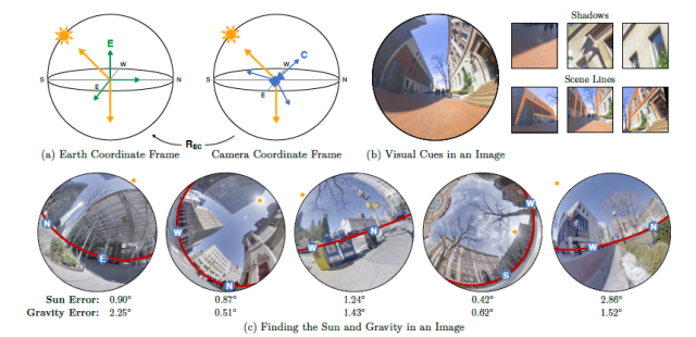 Figure 2: Camera orientation estimated from a single image. Visual cues reveal directions related to the sun and gravity; building and object shadows help identify the sun’s direction, while scene lines help identify gravity. The prediction examples and error notes are shown in the image source credit to Columbia University/Nayar Lab.
What the software estimates about light in a city
Standard methods can generate large errors because they do not capture how the brightness of the visible sky changes across the day and year, nor how light reflects off surrounding buildings. The team found that these reflections account for roughly 12% of a panel’s total annual energy, on average.
The laptop-based system forecasts the sun’s path through the visible sky across the day and year. It also estimates how much light bounces off surrounding buildings onto the panel, and uses historical weather data to extend the forecast beyond clear days to cloudy and overcast conditions.
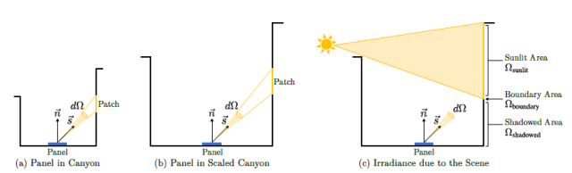 Figure 3: Scene irradiance properties for a panel in an urban environment. The image source is Columbia University/Nayar Lab. It shows how a panel’s irradiance can vary with sunlit and shadowed areas, using a Lambertian scene assumption.
To examine this behavior, the team used a physically based renderer to simulate scene irradiance as a function of the sun’s position. Researchers rendered the scene irradiance at 54,933 different locations for every sun position in a simulated Lambertian urban environment and performed principal component analysis. The result suggests that even complex city illumination can be described with a small number of coefficients.
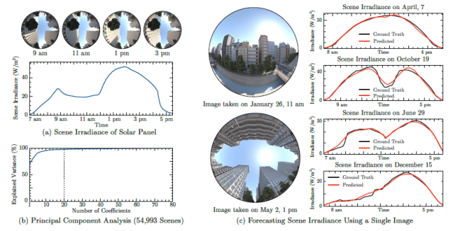 Figure 4: Forecasting scene irradiance from one image. The image source is Columbia University/Nayar Lab. It presents simulated daily irradiance, principal component analysis of rendered locations, and neural-network prediction results for different scenes and sun paths.
Based on those observations, researchers developed a neural network to predict a panel’s scene irradiance from a single image. The network uses a vision transformer backbone and a multilayer perceptron head that outputs scene irradiance for any sun position. The required measurement is one image, together with the capture time and the GPS location.
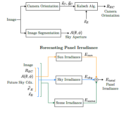 Figure 5: The complete pipeline for forecasting panel irradiance from one image. The image source is Columbia University/Nayar Lab. The process estimates sun and gravity directions, then forecasts irradiance due to the sun, sky, and scene, and sums those components for a total estimate.
What the conclusions mean for everyday city solar
A common rule of thumb says the best fixed panel orientation points toward the equator, with a zenith angle equal to the panel’s latitude. That rule assumes a clear view of the sky, which is rare in urban settings. Instead, researchers showed that a single spherical image taken near an existing panel can identify the best fixed panel orientation, which may differ substantially from the rule of thumb. They also validated the approach using actual irradiance measurements in the city’s tight, reflective streetside environment.
The work appears in a lengthy (23 pages!) but highly readable paper titled “Forecasting solar energy using a single image”, published in Solar Energy. The paper covers the problem, solution concept, alternatives, situation analysis, 3D geometries, city lighting realities, and optical considerations. Although the formal posting is behind a paywall, an open version is posted at arXiv, a free, open-access repository that hosts scholarly research papers before formal peer review and journal publication.
A quick checklist before choosing a fixed angle
- Capture one spherical photo from the planned mounting position, not only a street-level snap.
- Record the GPS location and the time of day for the photo, because the method uses those inputs.
- Note shadows, windows, roof edges, and small structures that could affect light paths.
- Do not rely only on latitude; city sky visibility can differ from the open-sky rule.
- Look for gains that may be possible without extra hardware or extra cost.
Common misconceptions, table form
| Belief | What the research discussion shows |
|---|---|
| Best tilt in any location is the equator-plus-latitude rule. | That rule assumes clear sky, rare in urban settings. |
| Reflections are a small footnote in a city. | Reflections were found to account for roughly 12% of annual energy on average. |
| A full site model always sees what matters. | A 3D model can miss small nearby structures that affect light paths. |
| More capture requires added mechanical tracking. | The study discusses a fixed panel orientation estimated from one photo, with reported capture gains of 10% to 30%. |
FAQ for general readers
- Q: Why is city solar placement different from a rooftop in an open area? Nearby buildings, shadows, reflections, and limited sky view change the light path. In an open area, aiming toward the sun is more direct.
- Q: Does the method require a new physical tracker? No. The article describes a fixed orientation estimated from one spherical image, aiming for better capture without extra cost.
- Q: Can the photo be taken anywhere nearby? The method uses an image from the target site and the capture time plus GPS location; the described insight is that the site view carries useful light-path information.
- Q: Are reflections really large enough to matter? The team reported that reflections from surrounding buildings account for roughly 12% of a panel’s total annual energy, on average.
- Q: Where can readers follow the paper? The paper titled Forecasting solar energy using a single image appeared in Solar Energy; an open version is posted at arXiv.
Action advice for everyday readers
- If you are choosing a fixed tilt for a small city solar device, treat the site as part of the design, not just a mounting bracket.
- Before assuming the panel should simply point at the highest sun, take one careful spherical photo at the installation point and check the sky view, shadows, and reflective surfaces.
- For public signage, kiosks, and charging stations, ask installers to evaluate local light capture rather than relying only on a generic latitude rule.
- Remember the reported opportunity: a better fixed orientation may improve capture by 10% to 30% without extra cost.
For MyTechDailyNews readers, the takeaway is practical: dense cities make solar planning a site-by-site decision. The research suggests that one image, plus location and time, can reveal enough about sky visibility and reflected light to choose a stronger fixed angle. The value is not only in the number, but in the method of looking at the panel’s own environment before locking it in place.